High Rocks Boulders
Quality bouldering in a high altitude forested setting in the upper Clackamas River valley
InformationQuality bouldering site located near High Rocks peak on the upper Clackamas River at the 4,000' elevation. Bouldering grades range from VB to V-double digits. Stones range in size from 8' to 25' tall/long, yet most landings are easy to pad. Numerous problems, most commonly from VB-V7, and minimal moss/lichen.
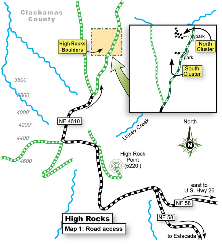
The site has two main core zones of interest — the south talus slope zone (which has two large stones), and the north talus slope zone. The north talus zone is the preferred zone that most boulderers tend to gravitate to because it has a plethora of problems to play upon — all packed in a very compact zone spread over roughly 250' across (minus the other outlier stones). North talus zone: GPS: lat-lon 45.174695° -121.891761° South talus zone: GPS: lat-lon 45.173571° -121.891764° Seasonal factors: Access limited to about 5 months (June-Oct), depending upon the snow pack. Road factors: Good paved roads to within 1/2 mile of the site, then a good gravel road the remainder of the distance. Extra note: 1. For those who live near U.S. Hwy 26 (east Portland) its 20-minutes faster to drive up past Govie Camp, then US Hwy 26 to the Timothy Lake turn-off, then paved back road NF58 to the site. Potholes exist on this backcountry paved road so beware. 2. For those who live to the south of Portland it's best to drive Hwy 224 south past Estacada along the Clackamas River, then east from Ripplebrook, then north up NF58 to the site. Recommendations: ■ It is recommended that you bring 1-2 crashpad for most of the common problems (2-4 crashpads if you need a well padded landing). ■ No cell phone reception (yet spotty text messaging if you're on certain cell plans). |
|
Directions
Directions via US Hwy 26:
- Drive east on US Hwy 26 past Govie Camp, then south on US Hwy 26 to the Timothy Lake turn-off. Drive NF42 road for ONLY 1 mile, then west on paved road NF4290 for 2.5 miles, where it lands at a 'T' intersection. Go left on paved road NF2660 for .8 mile where it 'T' intersects with Abbott road / NF58 road. Turn right on the paved road and drive on NF58 road for 9.4 miles to the major junction of NF58 east / NF58 south / NF4610 west roads.
- From this major junction go west! Drive west on NF4610 for 1.75 miles (as it wraps around the H.R. peak and passes by the pullout for High Rocks peak) - go to the end of the paved road. The NF4610 paved road ends here at this spot at a 'Y' intersection where the road splits.
- Stay on the main gravel road going rightward (NF230) as it travels northward (you will know your on the correct road because it has great views of Mt Hood here), and go about 1/2 mile on gravel. The first South Talus Field zone of boulders is obvious (park there if you plan to tap those).
- Or...drive a mere 500-feet north to another (inobvious wide spot). A narrow foot path enters uphill into the forest here. Follow that path uphill west for 200' to the main cluster of stones.
Recommendations
- It is recommended that you bring 2-4 crashpads for most of the common problems (especially if you like a well padded landing).
- No cell phone reception (spotty text messages).
